
Urban Forest Canopy Modelling
Aeroquest Mapcon can use new or existing LiDAR data to perform urban forest canopy modelling and analysis to provide detailed information about tree canopy coverage, crown heights and tree types, and can also include additional attributes such as parcel id, zoning class, individual tree identifiers, and locations. Benefits of establishing and maintaining an accurate forest canopy include:
Provides cities with detailed canopy modelling of a valuable asset that is important to the urban ecosystem and landscape.
Assists in urban and rural tree management budgeting.
Measures changes in tree growth, removal and mortality.
Assist in monitoring canopy coverage, carbon management and pervious landscape analysis.
Modelling the Tree Canopy
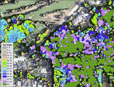
Using the LiDAR LAS files, tree crown polygons and treetop elevation points are generated as shown below. This data set will then be used to create a set of base attributes for each tree polygon which can vary depending on the needs of the client.

Tree identification diagram

Identified tree crowns shown as white points

Tree polygons showing crown size
Tree Crown Attributes
Attributes can either be derived directly from the tree points and polygons as Base Attributes, and/or include Additional Attributes from existing client information such as:
Additional Attributes
city
parcel id
parcel type
zoning class
zone description
park id
park name
city owned
Base Attributes
tree id
data year
height
height class
ground elevation
conifer / deciduous indicator
tree location (xyz)
crown density per hectare
crown area
Data Queries
The urban forest canopy modelling allows queries to be performed on each of the assigned Base and Additional Attributes items included with the project. These queries can be used for data analysis and displayed in a table or graphically as shown below.

Project-wide query showing tree height classes
Selected area graphical query showing tree height classes